
St Alband District Council (SADC) - Local Plan
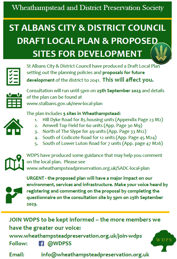
How the draft Local Plan affects Wheathampstead
The draft Local Plan makes provision for a whopping 25% increase in the number of houses in the district by 2041. However, the planned expansion of Wheathampstead is more in the region of 10% expansion. This is similar in size to the growth in housing stock in the village in the last 25 years.
However, the proposed development is almost exclusively on the Green Belt without due consideration to infrastructure (e.g.traffic, doctors, sewage), climate change and protection of the natural environment (e.g protection of local river water quality and ecosystems), requirements and employment opportunities within the village.
If you feel strongly about the proposals in the draft Local Plan, now is the time to let SADC know your views.
WDPS comments submitted to SADC on its draft Local Plan - we await their responses to all the comments received.
WDPS comments on Draft Local Plan
WDPS draft Impact Assessment on the plan’s proposals as they affect Wheathampstead. We believe such an assessment helps to identify the balance of pros and cons of SADC proposals.
At this stage it is in draft format, and we would be happy to work on it further if SADC find it a helpful and worthwhile document. We have asked them to let us know.
We have also suggested that a similar exercise for other areas of the District would be valuable.
Watch the SADC explanatory video
You can view the SADC video that explains why they are producing a Local Plan on this link.
It is important for District Councils to have a curent local plan and sadly SADC’s Local Plan is very out of date. Not having a Local Plan leaves the District open to unintended planning applications being accepted during a planning appeals process. But this does not mean the plan should be rushed through with inappropriate content.
Take part in SADC quick survey
You can take part in a quick survey to let SADC have your views on priorities for the District Plan by acessing this link.
Click here to take part in the quick SADC survey on priorities:
General background to the SADC Local Plan
WDPS accepts the need for SADC to have an up-to-date robust Local Plan. The current plan dates back to 1994 and is wholly inadequate 30 years later.
However, SADC are using out of date data (2014 population projections) from the Government on the housing requirements for the District. It is widely accepted that the data the Government has used will be amended in the near future, and it is expected that the population predictions will reduce significantly.
The Council has failed to take account of the National Planning Policy Framework (NPPF) as revised in July 2021, paragraph 11, footnote 7. This permits local planning authorities to restrict the scale of development due to planning constraints including protection of Green Belt and other designated areas and sites.
WDPS response to SADC regarding their local plan
Please use this information to help you formulate your own views about an appropriate response to SADC. These are purely suggestions on points you might like to raise - in addition to any personal views you may have. Please use your own words as a tailored and personal response to SADC will carry more weight.
WDPS comments on St Albans City and District Council Draft Local Plan
Wheathampstead and District Preservation Society (WDPS) has approximately 400 households as members, and we therefore speak for around 15% of the population of the Wheathampstead area.
Population Growth Projections
The Plan currently assumes that a staggering 25% increase in the number of dwellings is required in the District. This may be in line with National Planning Policy Framework as it currently stands, but in the light of the demographic changes that have taken place since the NPPF was last published, it is clear that the Government will shortly scale down its projections for future population growth.
The Office for National Statistics projects a 0.7% growth in population for St Albans from 2018 to 2028 with the main growth coming from the 65+ age range. Even projecting this level of growth growth to 2041 would not remotely justify a 25% increase in the number of dwellings.
We appreciate, given that the current plan dates from 1994, that a new Plan should be produced with some urgency, but it is wholly inappropriate to issue a Plan in which future housing needs are grossly overestimated.
We believe that either the Council should wait until the Government has amended the NPPF or base the Plan on best estimates of the latest projections for population growth. If necessary, the Plan could reflect two scenarios: one which shows the dwelling numbers required in the unlikely event of the NPPF remaining unaltered, and one based on the overwhelmingly more likely eventuality that the projection for future population growth will reduce substantially.
Green Belt Protection
All the sites for development that are proposed around Wheathampstead would be on Green Belt land. The protection of the Green Belt should be a major concern for the Council, but there is little evidence of this in the Plan.
The Council has failed to take account of the National Planning Policy Framework (NPPF) as revised in July 2021, paragraph 11, footnote 7. This permits local planning authorities to restrict the scale of development due to planning constraints including protection of Green Belt and other designated areas and sites.
The proposed developments at Amwell Top Field (M9) and the area north of the Slype in Gustard Wood (M12) are within the Green Belt buffer zone, which is designed to reduce the impact of existing development on the character of the Green Belt. This reduction of impact would be lost as a result of these developments.
The St Albans Stage 2 Green Belt Review completed by Ove Arup & Partners in 2023 concluded that the Green Belt around Wheathampstead contributes significantly to purpose 4 of the Green Belt, namely, to safeguard the countryside from encroachment. Only one of the Wheathampstead sites proposed for development in the Plan, the area south of Hilldyke Road, is identified by Arup as one of the areas in the District that contributes least to the Green Belt purposes.
The need to provide affordable housing should not be seen as a justification for building on the Green Belt, as the average house price at the proposed sites would almost certainly be beyond the means of those for whom affordable housing is designed.
Traffic
However many dwellings are constructed there will inevitably be an increase in traffic. The main roads in and out of Wheathampstead, especially the B651 and the B653, are already very busy. Both roads are extremely narrow in parts and have been getting busier and busier in the last few years with regular growing traffic tailbacks at busy times. On the B651 in and around Sandridge, new dwellings are already being constructed increasing already heavy traffic volumes. The B651 in particular is regularly used by cyclists and has a number of accident black spots where there have been serious accidents recently.
It would not be a good idea to allow traffic to increase significantly further on these roads because that would give rise to an unacceptable level of congestion. Careful consideration needs to be given as to how traffic from any new development would feed into these routes without causing undue congestion.
New developments also need to be sited and designed so that the impact on country lanes and residential streets is minimised.
A significant increase in road traffic would cause air quality to suffer further in the medium term, which in turn would have a detrimental impact on health.
Public transport, which has been declining, should be improved to meet the needs of a larger population, and cycling should be encouraged.
Many people will continue however to use their cars, and the car park in the centre of Wheathampstead must remain free to use in order to discourage parking in the busy High Street or in nearby residential roads.
Employment Opportunities
The Plan does not make provision for the additional employment that an increased population will need other than in the Protected Employment Areas, both of which are remote from Wheathampstead. Only one existing employment area in Wheathampstead, Place Farm, is protected. (The reference to Codicote Road is presumably a mistake.)
In order to minimise any increase in commuter traffic, employment opportunities should be provided in larger new developments.
Much of the life and character of Wheathampstead would be lost if a higher proportion of residents worked outside the village. If Wheathampstead were to become a dormitory village, footfall in the village centre would plummet and the High Street could become mainly residential.
Factors Outside Wheathampstead
Wheathampstead would of course also be affected by nearby development outside its borders. The large-scale development at Batford (B2) would vastly increase the amount of traffic using the already very busy B653 through both Batford itself and Wheathampstead.
A further threat comes from the possibility of developments outside the District. In particular, the proposed expansion of Luton Airport would have a major impact on our area in terms of traffic, pollution and noise.
The combination of these external factors and the developments proposed within Wheathampstead itself would put an enormous and unacceptable strain on local roads and would vastly increase noise and pollution levels.
Utilities and Local Services
There is little mention in the Plan of utilities such as water and waste. If there is to be any increase in population, it will be vital that these are adequately provisioned. The impact on local services including doctors, dentists and schools, some of which are already under pressure, needs to be carefully assessed and proper plans made.
Environmental Issues
Biodiversity issues and the protection of natural resources receive scant attention in the Plan despite the significant loss of Green Belt land that the Plan envisages. The need to respond to climate change is dealt with in only a very general way.
Development Sites in Wheathampstead
WDPS is concerned about all development on Green Belt land unless there are exceptional circumstances, and as mentioned above there is provision in the NPPF for local planning authorities to restrict the scale of development to permit the protection of the Green Belt.
WDPS opposes two of the proposed development sites: Amwell Top Field (M9) and the area north of the Slype in Gustard Wood (M12). Both protrude from the existing built-up area and encroach on the countryside.
We understand that development at the Amwell site would be limited to half of the Top Field. We trust that this would be in the northern half closest to the village and we would urge that the Plan map be re-drawn to highlight only that part of the field where development is proposed. You will have received details about the high pressure gas pipe that crosses Top Field, and the suitability of the site must be reviewed in the light of this information.
Conservation Officer
We understand that the former Conservation Officer at SADC studied the Plan before she left and indeed raised objections to the site at Amwell Top Field (M9). We trust that another Conservation Officer will be appointed soon and will be asked to comment on any future changes to the Plan.
Recent Development in Wheathampstead
Finally, we should like to dispel any suggestion that there has been little or no development in Wheathampstead in recent years and that it is now Wheathampstead’s ‘turn’ to accommodate new housing estates.
In addition to various small sites, the major housing developments over the past 25 years have been the former Murphy Chemical site (Waddling Lane, Palmerston Drive, Dawes Lane and Pikes Leap) [73 dwellings], Old Waddling Lane and Abbot John Mews [11 dwellings], the former Wheathampstead Education Centre site (south of Butterfield Road) [approx. 75 dwellings], King Edward Place [24 Dwellings], Moat House [6 dwellings] and the former reed bed site (Melbourne Mews) [29 dwellings]. This totals at least 218 houses – about a 10% increase in housing stock for the village.
Summary
Considering the comments above, we urge you to revisit your draft Local Plan and produce a more equitable balanced plan that really serves the needs of the St Albans District residents.
Comments by CPRE Hertfordshire
You might also find it helpful to review the comments from CPRE Hertfordshire using this link:
